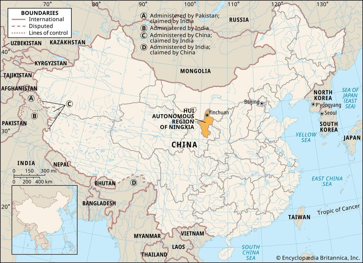
Ningxia is not what most people expect when they think of north-central China. It is an autonomous region sandwiched between Gansu to the south, Shaanxi to the east, and the vast stretches of Inner Mongolia to the north. The geography is stark. Most of this 25,600-square-mile landmass is desert. But there is a reason travelers are starting to look here.
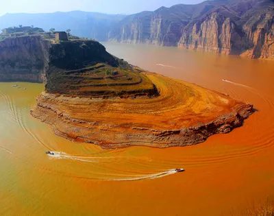
The Huang He, or Yellow River, cuts through the northern part of the region. For centuries, farmers have used its waters to irrigate the Ningxia plain. This creates a sharp contrast. You have sand dunes on one side and lush, green paddy fields on the other. The capital, Yinchuan, sits just west of the river in this northern section. It is the gateway to a place that feels like a different world.
The Geography of Contrast
To understand where you are going, you need to look at the land. Ningxia splits into two distinct zones. Southern Ningxia sits on the Loess Plateau. Here, the Liupan Mountains form the main ridge. The ground is covered in loess, a wind-blown soil that can be over 300 feet deep in some spots. The terrain is relatively flat under that thick layer of earth.
Northern Ningxia is defined by the Huang He plain. The river flows in from the Qinghai plateau, moving east before turning north into Inner Mongolia. To the west of this plain stand the Helan Mountains. These mountains are not just scenery. They act as a physical barrier, shielding the farmland from sandstorms rolling in from the Tengger Desert. Without them, the agriculture here would likely fail.
The plain itself sits at an elevation of 3,600 to 3,900 feet. It slopes gently from south to north. It is arid. Yearly precipitation on the plain ranges from only 8 to 24 inches. Yet, the landscape often looks like southern China. How? Because of the canals. Built over centuries, these willow-lined waterways turn the arid soil into productive fields. It is a testament to human persistence in a harsh climate.
A Harsh but Manageable Climate
The weather here is continental. You need to pack for extremes. The annual average maximum temperature hits 80 °F. The minimum drops to 7 °F. That is a significant swing. If you are planning a trip, timing is everything.
“The climate of Ningxia is continental. Temperatures range from an annual average maximum of 80 °F to an annual average minimum of 7 °F.”
Precipitation is low. You cannot rely on rain to water the crops or cool the air. The irrigation systems are the lifeline. Understanding this helps you appreciate the logistics of travel here. You are walking through a landscape shaped by water management as much as by nature.
The People and History
This land has been contested for a long time. The region was once the heart of the Tangut people’s kingdom, known as Xi (Western) Xia. It was a powerful entity until Genghis Khan conquered it. The name Ningxia, meaning “Peaceful Xia,” dates back to that period. It is a reminder that this place has always been a crossroads.
Today, about 7.2 million people call this region home. They live in a mix
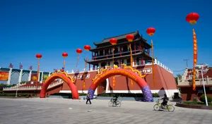
Demographics and Daily Life
Ningxia is not a monolith. If you walk through the streets of Yinchuan or drift into the rural counties, you will see a complex tapestry of identities. The Han Chinese make up the majority, yes. But here, the Hui Muslims are no afterthought. They constitute more than a third of the total population. This is the largest minority group in the region, and their influence is everywhere. You will see it in the architecture, the food, the rhythm of daily life.
Islam is the predominant religion here, with Buddhism trailing close behind. Nearly everyone speaks Mandarin Chinese. You might hear Tibetan or Mongolian spoken by smaller pockets of Tibetans, Mongols, and Manchu residents, but Mandarin is the lingua franca. It connects them.
Most of the region remains rural. It is one of China’s more sparsely settled areas. The population is engaged in pasturing and farming. In the scattered cities, there is a tradition of devotion to handicrafts. It is a slower pace. A different way of measuring time. Since 1949, however, the narrative has shifted. More workers have moved into mining and manufacturing. The capital, Yinchuan, has grown to become the largest city, absorbing these changes.
The Agricultural Heartland
The Ningxia plain is fertile. It produces abundant wheat. The rice here is good quality, unlike some of the softer grains found further south. How? An intricate system of ancient and new irrigation canals. This infrastructure has improved yields significantly, even though the use of chemical fertilizers remains well below the national average.
The region’s agriculture is defined by its irrigation canals and high-quality livestock, particularly the soft, white wool of its sheep.
Sugar beets are the main cash crop. They drive the local economy. In the mixed agricultural and pastoral areas, you will find a high-quality breed of sheep. It is a domesticated form of the argali from eastern Mongolia. The wool is soft, white, and lustrous. It commands attention.
The Manchu people, in particular, have long been known for breeding and raising pigs. They also grow melons, apricots, and other fruits in quantity. These fruits are not just sustenance. They are exports. They are flavor.
Minerals and Energy
Look down, and you will find coal. The mineral resources of Ningxia consist mainly of coal reserves. There are four main coal fields dispersed throughout the region. They are located in the north near the Inner Mongolian border. Around Xiangshan in the west-central area. Near Lingwu in east-central Ningxia. And around Guyuan in the south.
Coal was mined on a small scale in the past. That changed with the construction of the Baotou-Lanzhou railroad in 1958. Expansion followed. The region is now one of the major bases of coal mining and thermal power generation in northern China. Since the early 21st century, a large base for the production of energy and chemicals has been under development in eastern Ningxia, known as Ningdong.
There are other resources, too. Reserves of petroleum. Natural gas. Gypsum. Quartz sandstone. Barite. Silex (silica). Limestone. These are not just geological footnotes. They are economic drivers.
Yinchuan: The Hub
Yinchuan sits in the center of the Ningxia plain. It was well known in ancient times as a border city on the western frontier of China. Until the mid-20th century, it was largely a trading center for farm and animal products. The Huang River, to the east, provides irrigation and facilities for water transportation. It has always been a place of exchange.
Medium-sized and even large factories have since been built there. Industry has grown steadily. Natural resources and agricultural products such as wool and sugar form the foundation of many enterprises. The nearby coal reserves led to the development of a chemical industry in Yinchuan. The region also produces machinery. Building materials. Consumer goods such as paper, foodstuffs, and wool and cotton fabrics.
Transportation has played a huge role in this growth. An extension of the main railway between Beijing and Baotou (in Inner Mongolia), completed in 1958, links Yinchuan to two major regional industrial bases. Baotou to the northeast. Lanzhou (in Gansu) to the southwest. Subsequent branch lines extend south to Baoji in Shaanxi province and west to Wuwei in Gansu province.
Several highway and express-highway bridges built across the Huang He since the early 1970s have further stimulated regional economic development. Expressways run from Shizuishan in the north to Zhongwei in the west and to Guyuan in the south. Yinchuan is the hub of Ningxia’s air travel. It connects the interior to the rest of the world.
Education and Society
Ningxia was formerly a backward area in education. The numbers from 1935 tell the story. There were only two high schools. Two normal (teacher-training) schools. About 200 elementary schools. Very few children attended. The literacy rate was low. Illiteracy was widespread.
Since the communist government was organized in 1949, there has been much improvement. Illiteracy has been markedly reduced. The landscape of learning has changed.
Ningxia University in Yinchuan is the region’s main institution of higher education. Descended from schools founded in 1958, it was designated a university in 1962. It underwent further reorganizations in 1997 and 2002, each time incorporating other higher-education facilities. There are other higher-learning institutions across the region, including Ningxia Medical University (1958) in Yinchuan. Health care also has been transformed with the building of clinics and hospitals.
The shift from agrarian isolation to educational modernization is stark. The roads are built. The factories are humming. The universities are filled. But the soul of the place? That remains in the fields. In the mosques. In the quiet persistence of a people who have learned to adapt without forgetting where they started.
You can stand in Yinchuan and feel the weight of history. Or you can drive west into the dust and find the sheep. Both are true. Both are necessary. The choice of where to look defines the trip.
Navigating the Modern and Ancient Hui Experience
The image of the traditional Hui woman is one of strict domestic boundaries. She stayed inside. The veil hid her face when she stepped out. She didn’t speak to men. It was a rigid code. But walk through Yinchuan today and that code feels distant, if it ever truly applied everywhere.
Hui women are farming now. They work in factories. In the cities, you’ll see Western fashion replacing traditional garments. The culture hasn’t vanished, but it has shifted. It’s breathing differently.
What to See Around Yinchuan
Yinchuan is the cultural heartbeat of Ningxia. Start there.
You don’t have to look far for history. The area is dotted with Buddhist architecture from the Xi Xia period. Head west, about 22 miles (35 km) out of town, to find the imperial and royal Xi Xia tombs. They stand silent against the landscape.
If you’re interested in fortifications, northern Ningxia holds up. Long sections of the Great Wall survive here. You can access them from Yinchuan or nearby stops. It’s not the crowded Mutianyu section you might know. It’s wilder. Rawer.
The Triangle of Stone
Travel south from Yinchuan, roughly 30 miles (50 km) toward Qingtongxia. Look for the Huang He river. On a hillside nearby, you’ll find the 108 Pagodas.
They are from the Yuan dynasty (1206–1368). Each pagoda stands between 8 and 11.5 feet (2.5 to 3.5 meters) tall. They aren’t scattered randomly. They are arranged up the slope in the shape of a large triangle. It’s a geometric puzzle carved in stone.
The 108 Pagodas are arranged in a massive triangle, a silent testament to Yuan dynasty engineering.
Deep Cuts and High Peaks
Keep moving south. We are leaving the yellow earth of the plains and entering the ancient routes.
About 35 miles (55 km) northwest of Guyuan, near the northern route of the Silk Road, lies Mount Xumi. Here, the cliff faces are riddled with grottoes. The statues inside are well-preserved. They date from the 6th to the 10th century. One statue towers over the rest. It’s more than 65 feet (20 meters) high. Stand beneath it and you understand why pilgrims came here for centuries.
Further south, the Liupan Mountains rise up. They are a major tourist destination. The air is cooler there. The landscapes shift from arid plains to rugged peaks. It’s a stark contrast to the desert edges.
A Turbulent Past
This land has always been a borderland.
In the 3rd century BCE, the Qin empire pushed south of the Huang He. They built walls. They dug irrigation canals. Those canals from the Qin, Han, and Tang dynasties still prove the area has been inhabited for millennia. You can trace the water that fed these ancient settlements.
The 11th century brought the Xi Xia kingdom. The Tangut people took charge. Then came Chinggis Khan. He captured Yinchuan in the early 13th century. The region became tributary to China, but the power dynamics were always shifting.
As Mongol power waned, Turkish-speaking Muslims moved in from the west. Islamic influence took root. Muslim settlers maintained their separateness. They didn’t blend in. They held their own.
The mid-19th century saw a general Muslim revolt in the northwest. Tension between Han and Hui communities lingered well into the 20th century. After 1911, Muslim warlords took control. The Ma clan of Hezhou, Gansu, built a political base here.
The region played all sides. The Nationalist Party wooed them. The Japanese tried to capture their allegiance. The Russians made their moves. It was an arena of conflict between World Wars I and II.
Modern Borders and Military Shifts
In 1914, Ningxia became part of Gansu province. It wasn’t until 1928 that it was constituted as its own province.
During the Sino-Japanese War (1937–45), parts of Ningxia were incorporated into the Shaan-Gan-Ning border region. Communist authorities courted minority support there. They promised cultural and political rights. Some Hui leaders joined them. Most Ningxia Hui, however, stuck with the Ma clan.
The end came in battle. The People’s Liberation Army defeated the Ma clan armies.
From 1949 to 1954, the Northwest Military Administrative Committee held authority. Then, Ningxia was made directly subordinate to the central government, still tied to Gansu. Autonomous Hui prefectures were established on the irrigated plains and in the Liupan foothills.
In 1958, these areas merged to form the Hui Autonomous Region of Ningxia. The borders shifted again. Part of the Tengger Desert was incorporated in 1969, only to revert to Inner Mongolia in 1979.
Today, the region is developing fast. Mineral resources drive the economy. Transportation infrastructure is expanding. The history is heavy. The future is moving quickly. You can feel both in the streets of Yinchuan.